
Make a donation
Gear up for your next adventure:
As an Amazon Associate, this site earns from qualifying purchases at no extra cost to you.
Middelheers topographic map
Click on the map to display elevation.
Make a donation
Gear up for your next adventure:
As an Amazon Associate, this site earns from qualifying purchases at no extra cost to you.
About this map
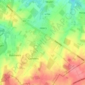
Name: Middelheers topographic map, elevation, terrain.
Location: Middelheers, Heers, Tongeren, Limburg, Vlaanderen, 3870, België (50.72425 5.28116 50.76425 5.32116)
Average elevation: 315 ft
Minimum elevation: 197 ft
Maximum elevation: 436 ft
Make a donation
Gear up for your next adventure:
As an Amazon Associate, this site earns from qualifying purchases at no extra cost to you.
Other topographic maps
Click on a map to view its topography, its elevation and its terrain.
Heers
België > Limburg > Tongeren > Heers
Heers ligt op een hoogte van 132 meter op het hoogste punt van een plateau in Droog-Haspengouw. Het gebied is rijk aan reliëf, en het laagste punt is ongeveer 75 meter. De landbouw die hier beoefend wordt omvat suikerbietenteelt, en ook de fruitteelt is van belang. Heers ontstond bij het brongebied van de…
Average elevation: 305 ft