
Make a donation
Gear up for your next adventure:
As an Amazon Associate, this site earns from qualifying purchases at no extra cost to you.
Voiron topographic map
Click on the map to display elevation.
Make a donation
Gear up for your next adventure:
As an Amazon Associate, this site earns from qualifying purchases at no extra cost to you.
Voiron
The city is located 25 km (16 mi) northwest of Grenoble and 85 km (53 mi) southeast of Lyon. Voiron is at an altitude of 290 metres (950 feet), on the Morge (a tributary of the Isère).
Make a donation
Gear up for your next adventure:
As an Amazon Associate, this site earns from qualifying purchases at no extra cost to you.
About this map
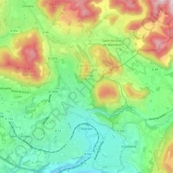
Name: Voiron topographic map, elevation, terrain.
Average elevation: 1,604 ft
Minimum elevation: 784 ft
Maximum elevation: 3,077 ft
Make a donation
Gear up for your next adventure:
As an Amazon Associate, this site earns from qualifying purchases at no extra cost to you.
Other topographic maps
Click on a map to view its topography, its elevation and its terrain.
Make a donation
Gear up for your next adventure:
As an Amazon Associate, this site earns from qualifying purchases at no extra cost to you.
Lac de Paladru
France > Auvergne-Rhône-Alpes > Isère > Paladru
The lake area has a cool temperate climate. The north–south orientation and relatively high altitude means the average temperature is around 10 °C. Rainfall is irregular, with most rain occurring in June and October with the rise of humid air masses from the Mediterranean. January is the coldest month, with…
Average elevation: 1,867 ft
Make a donation
Gear up for your next adventure:
As an Amazon Associate, this site earns from qualifying purchases at no extra cost to you.
Make a donation
Gear up for your next adventure:
As an Amazon Associate, this site earns from qualifying purchases at no extra cost to you.
Make a donation
Gear up for your next adventure:
As an Amazon Associate, this site earns from qualifying purchases at no extra cost to you.
Hameau des Farlaix
France > Auvergne-Rhône-Alpes > Isère > Autrans-Méaudre en Vercors > Méaudre
Average elevation: 3,789 ft
Les Brunières
France > Auvergne-Rhône-Alpes > Isère > Saint-Quentin-sur-Isère
Average elevation: 1,388 ft
Make a donation
Gear up for your next adventure:
As an Amazon Associate, this site earns from qualifying purchases at no extra cost to you.
Uriage Les Bains
France > Auvergne-Rhône-Alpes > Isère > Saint-Martin-d'Uriage
Average elevation: 2,028 ft
Roche Béranger
France > Auvergne-Rhône-Alpes > Isère > Chamrousse
The road to the ski station starts at Uriage-les-Bains from where the climb is 19 km (12 mi) long, gaining 1,235 m (4,052 ft) in elevation, at an average gradient of 6.5%. There are several sections in excess off 11% in the early stages of the climb. For the Tour de France, the summit is at an elevation of…
Average elevation: 5,121 ft
Make a donation
Gear up for your next adventure:
As an Amazon Associate, this site earns from qualifying purchases at no extra cost to you.
Make a donation
Gear up for your next adventure:
As an Amazon Associate, this site earns from qualifying purchases at no extra cost to you.
Les Bourdoires
France > Auvergne-Rhône-Alpes > Isère > Saint-Laurent-du-Pont
Average elevation: 2,060 ft
Make a donation
Gear up for your next adventure:
As an Amazon Associate, this site earns from qualifying purchases at no extra cost to you.
Make a donation
Gear up for your next adventure:
As an Amazon Associate, this site earns from qualifying purchases at no extra cost to you.
Pic du Lac Blanc
France > Auvergne-Rhône-Alpes > Isère > Le Freney-d'Oisans
Average elevation: 9,554 ft
Make a donation
Gear up for your next adventure:
As an Amazon Associate, this site earns from qualifying purchases at no extra cost to you.
Les Beauches
France > Auvergne-Rhône-Alpes > Isère > Le Sappey-en-Chartreuse
Average elevation: 3,517 ft
Make a donation
Gear up for your next adventure:
As an Amazon Associate, this site earns from qualifying purchases at no extra cost to you.