Geolocate

Dunton topographic map

Click on the map to display elevation.

About this map

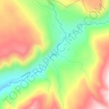
Name: Dunton topographic map, elevation, terrain.

Location: Dunton, Dolores County, Colorado, United States (37.75277 -108.11396 37.79277 -108.07396)

Average elevation: 9,606 ft

Minimum elevation: 8,625 ft

Maximum elevation: 10,689 ft

Dolores County trails, hiking, mountain biking, running and outdoor activities

Gear up for your next adventure:

🛰️Handheld GPS Units - Professional satellite navigators for precise backcountry mapping
🪶Multi‑Purpose Knife - Useful blade for camp and trail
🥤Water Filter Bottle - All‑in‑one filter bottle for safe hydration
🔌Solar Panel Charger - Charge gear sustainably outdoors
🥾Men's Hiking Boots - Durable, waterproof footwear for rugged terrain and steep inclines

As an Amazon Associate, this site earns from qualifying purchases at no extra cost to you.