
Make a donation
Gear up for your next adventure:
As an Amazon Associate, this site earns from qualifying purchases at no extra cost to you.
New Gloucester topographic map
Click on the map to display elevation.
Make a donation
Gear up for your next adventure:
As an Amazon Associate, this site earns from qualifying purchases at no extra cost to you.
New Gloucester
The privately owned, unattended Cliff Dow Airport is located on Highview Drive, two miles southwest of New Gloucester, to the east of Interstate 95. Its FAA identifier is 54ME, and it was activated in 2006. Its unpaved runway headings are 5 (for landings) and 23 (for takeoffs) with an AMSL elevation of 415 feet. Its area control center is Boston Center, while its flight service station is Bangor.
Make a donation
Gear up for your next adventure:
As an Amazon Associate, this site earns from qualifying purchases at no extra cost to you.
About this map
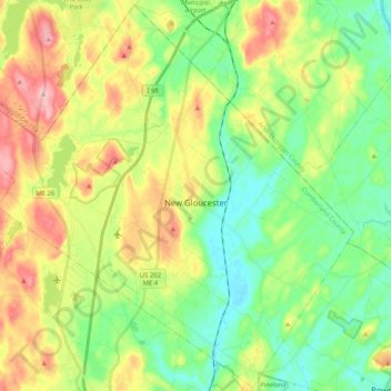
Name: New Gloucester topographic map, elevation, terrain.
Average elevation: 285 ft
Minimum elevation: 82 ft
Maximum elevation: 627 ft
Cumberland County trails, hiking, mountain biking, running and outdoor activities
Make a donation
Gear up for your next adventure:
As an Amazon Associate, this site earns from qualifying purchases at no extra cost to you.
Other topographic maps
Click on a map to view its topography, its elevation and its terrain.
Cliff Island
United States > Maine > Cumberland County > Portland > Cliff Island
Average elevation: 3 ft
Make a donation
Gear up for your next adventure:
As an Amazon Associate, this site earns from qualifying purchases at no extra cost to you.
Make a donation
Gear up for your next adventure:
As an Amazon Associate, this site earns from qualifying purchases at no extra cost to you.