
Make a donation
Gear up for your next adventure:
As an Amazon Associate, this site earns from qualifying purchases at no extra cost to you.
Granollers de Rocacorba topographic map
Click on the map to display elevation.
Make a donation
Gear up for your next adventure:
As an Amazon Associate, this site earns from qualifying purchases at no extra cost to you.
About this map
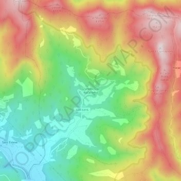
Name: Granollers de Rocacorba topographic map, elevation, terrain.
Average elevation: 1,808 ft
Minimum elevation: 879 ft
Maximum elevation: 2,835 ft
Make a donation
Gear up for your next adventure:
As an Amazon Associate, this site earns from qualifying purchases at no extra cost to you.
Other topographic maps
Click on a map to view its topography, its elevation and its terrain.
Serralada Transversal
España > Cataluña > Gironés > Sant Martí de Llémena
La comarca de Collsacabra o Cabrerés da nombre a una parte de estas montañas, situadas entre la sierra de Cabrera, el valle del río Ter al sur, en el pantano de Sau, y el Vall de Bas y Las Planas, al este. La sierra de Cabrera posee la máxima altitud (1303 m), al norte, y desde aquí se extiende un…
Average elevation: 1,260 ft