
Eshowe topographic map
Click on the map to display elevation.
About this map
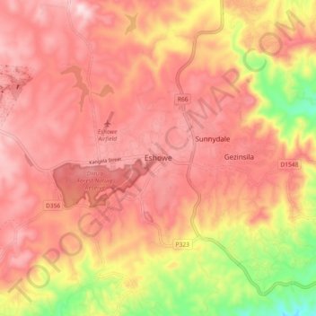
Name: Eshowe topographic map, elevation, terrain.
Average elevation: 1,499 ft
Minimum elevation: 699 ft
Maximum elevation: 1,923 ft
Other topographic maps
Click on a map to view its topography, its elevation and its terrain.
uThukela
South Africa > KwaZulu-Natal > King Cetswayo District Municipality > uMlalazi Local Municipality
The river originates in Mont-aux-Sources of the Drakensberg Mountains at an elevation of almost 11,000 feet and plunges 947 metres down the Tugela Falls. The Mont-aux-Sources is also the origin of tributaries of two other major South African rivers, the Orange and the Caledon River. From the Drakensberg range,…
Average elevation: 781 ft