
uThukela topographic map
Click on the map to display elevation.
uThukela
The river originates in Mont-aux-Sources of the Drakensberg Mountains at an elevation of almost 11,000 feet and plunges 947 metres down the Tugela Falls. The Mont-aux-Sources is also the origin of tributaries of two other major South African rivers, the Orange and the Caledon River. From the Drakensberg range, the Tugela follows a 531 km (330 mi) route through the KwaZulu-Natal midlands before flowing into the Indian Ocean. The total catchment area is approximately 29,100 km2 (11,200 sq mi). Land uses in the catchment are mainly rural subsistence farming and commercial forestry.
About this map
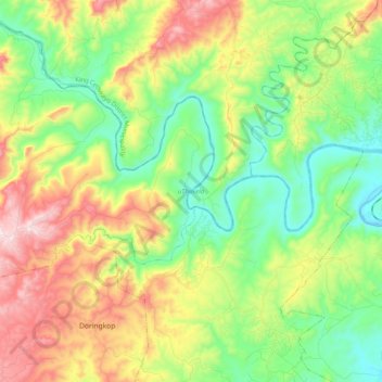
Name: uThukela topographic map, elevation, terrain.
Average elevation: 781 ft
Minimum elevation: 56 ft
Maximum elevation: 1,998 ft
Other topographic maps
Click on a map to view its topography, its elevation and its terrain.
Eshowe
South Africa > KwaZulu-Natal > King Cetswayo District Municipality > uMlalazi Local Municipality
Average elevation: 1,499 ft
Mtunzini
South Africa > KwaZulu-Natal > King Cetswayo District Municipality > uMlalazi Local Municipality
Average elevation: 98 ft
Amatikulu
South Africa > KwaZulu-Natal > King Cetswayo District Municipality > uMlalazi Local Municipality
Average elevation: 177 ft
eNtumeni
South Africa > KwaZulu-Natal > King Cetswayo District Municipality > uMlalazi Local Municipality
Average elevation: 2,549 ft
Eshowe
South Africa > KwaZulu-Natal > King Cetswayo District Municipality > uMlalazi Local Municipality
Average elevation: 1,499 ft
Eshowe
South Africa > KwaZulu-Natal > King Cetswayo District Municipality > uMlalazi Local Municipality
Average elevation: 1,499 ft
Eshowe
South Africa > KwaZulu-Natal > King Cetswayo District Municipality > uMlalazi Local Municipality
Average elevation: 1,499 ft
Mtunzini
South Africa > KwaZulu-Natal > King Cetswayo District Municipality > uMlalazi Local Municipality
Average elevation: 98 ft
eNtumeni
South Africa > KwaZulu-Natal > King Cetswayo District Municipality > uMlalazi Local Municipality
Average elevation: 2,549 ft
Eshowe
South Africa > KwaZulu-Natal > King Cetswayo District Municipality > uMlalazi Local Municipality
Average elevation: 1,499 ft