
Thank you for supporting this site ❤️
Make a donation
Make a donation
Gear up for your next adventure:
As an Amazon Associate, this site earns from qualifying purchases at no extra cost to you.
Miaoshen topographic map
Click on the map to display elevation.
Thank you for supporting this site ❤️
Make a donation
Make a donation
Gear up for your next adventure:
As an Amazon Associate, this site earns from qualifying purchases at no extra cost to you.
About this map
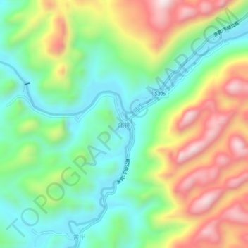
Name: Miaoshen topographic map, elevation, terrain.
Location: Miaoshen, Du'an Yao Autonomous County, Hechi, Guangxi, China (24.36097 107.98241 24.40097 108.02241)
Average elevation: 1,276 ft
Minimum elevation: 499 ft
Maximum elevation: 2,503 ft
Thank you for supporting this site ❤️
Make a donation
Make a donation
Gear up for your next adventure:
As an Amazon Associate, this site earns from qualifying purchases at no extra cost to you.