Geolocate

Mioño topographic map

Click on the map to display elevation.

About this map

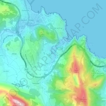
Name: Mioño topographic map, elevation, terrain.

Location: Mioño, Castro-Urdiales, Cantabria, 39709, Spain (43.33872 -3.22173 43.37872 -3.18173)

Average elevation: 289 ft

Minimum elevation: -7 ft

Maximum elevation: 1,434 ft

Gear up for your next adventure:

💧Water Purification System - Clean water on the trail with reliable purifiers
🏕️Tent Footprint - Protect your tent base from wear
🪶Paracord Bracelet - Survival bracelet with built‑in tools
🥩Freeze-Dried Meals - Nutritious and lightweight food for remote expeditions
🧭Hiking Compass - Precision compass for reliable navigation in the wilderness

As an Amazon Associate, this site earns from qualifying purchases at no extra cost to you.