
Thank you for supporting this site ❤️
Make a donation
Make a donation
Gear up for your next adventure:
As an Amazon Associate, this site earns from qualifying purchases at no extra cost to you.
Kisima topographic map
Click on the map to display elevation.
Thank you for supporting this site ❤️
Make a donation
Make a donation
Gear up for your next adventure:
As an Amazon Associate, this site earns from qualifying purchases at no extra cost to you.
About this map
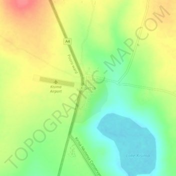
Name: Kisima topographic map, elevation, terrain.
Location: Kisima, Lodokejek ward, Samburu Central, Samburu, Kenya (0.92741 36.74571 0.96741 36.78571)
Average elevation: 5,879 ft
Minimum elevation: 5,774 ft
Maximum elevation: 5,994 ft
Thank you for supporting this site ❤️
Make a donation
Make a donation
Gear up for your next adventure:
As an Amazon Associate, this site earns from qualifying purchases at no extra cost to you.