Geolocate

Pallivasal topographic map

Click on the map to display elevation.

About this map

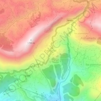
Name: Pallivasal topographic map, elevation, terrain.

Location: Pallivasal, Devikulam, Idukki District, Kerala, 685565, India (10.02978 77.03148 10.06978 77.07148)

Average elevation: 4,281 ft

Minimum elevation: 2,684 ft

Maximum elevation: 5,758 ft

Other topographic maps

Click on a map to view its topography, its elevation and its terrain.

Munnar Town

India > Kerala > Devikulam > Munnar

Average elevation: 5,207 ft

Gear up for your next adventure:

📡GPS Antenna Upgrade - Enhance GPS reception in remote terrain
🔥Fast-Boil Camping Stoves - Efficient cooking systems for quick trail meals
🏔️Mountain Trail Maps - High‑detail maps for popular peaks
📌Outdoor GPS Map App - Apps and devices for digital topographic navigation
🚑Emergency Bivvies - Heat-reflective sleeping bags for survival situations

As an Amazon Associate, this site earns from qualifying purchases at no extra cost to you.