
Calgary topographic map
Interactive map
Click on the map to display elevation.
About this map
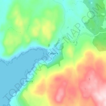
Name: Calgary topographic map, elevation, terrain.
Location: Calgary, Argyll and Bute, Scotland, PA75 6QU, United Kingdom (56.55891 -6.29676 56.59891 -6.25676)
Average elevation: 358 ft
Minimum elevation: 0 ft
Maximum elevation: 1,043 ft
Other topographic maps
Click on a map to view its topography, its elevation and its terrain.
Iona
United Kingdom > Scotland > Argyll and Bute > The Village
Iona, The Village, Argyll and Bute, Scotland, United Kingdom
Average elevation: 30 ft
Sandbank
United Kingdom > Scotland > Argyll and Bute
Sandbank, Argyll and Bute, Scotland, PA23 8PJ, United Kingdom
Average elevation: 328 ft
Port Bannatyne
United Kingdom > Scotland > Argyll and Bute
Port Bannatyne, Argyll and Bute, Scotland, PA20 0LW, United Kingdom
Average elevation: 171 ft
Tiree
United Kingdom > Scotland > Argyll and Bute > Balevullin
Tiree, Balevullin, Argyll and Bute, Scotland, United Kingdom
Average elevation: 10 ft
Colonsay
United Kingdom > Scotland > Argyll and Bute > Scalasaig
Colonsay, Scalasaig, Argyll and Bute, Scotland, United Kingdom
Average elevation: 36 ft
Loch Etive
United Kingdom > Scotland > Argyll and Bute > Connel
Loch Etive, Connel, Argyll and Bute, Scotland, United Kingdom
Average elevation: 1,043 ft
Campbeltown
United Kingdom > Scotland > Argyll and Bute > Campbeltown
Campbeltown, Argyll and Bute, Scotland, PA28 6AD, United Kingdom
Average elevation: 276 ft
Rothesay
United Kingdom > Scotland > Argyll and Bute
Rothesay, Argyll and Bute, Scotland, PA20 2AA, United Kingdom
Average elevation: 125 ft
Staffa
United Kingdom > Scotland > Argyll and Bute
Staffa, Argyll and Bute, Scotland, United Kingdom
Average elevation: 0 ft
North Connel
United Kingdom > Scotland > Argyll and Bute
North Connel, Argyll and Bute, Scotland, PA37 1PL, United Kingdom
Average elevation: 62 ft