
Thank you for supporting this site ❤️
Make a donation
Make a donation
Gear up for your next adventure:
As an Amazon Associate, this site earns from qualifying purchases at no extra cost to you.
Yeraltı topographic map
Click on the map to display elevation.
Thank you for supporting this site ❤️
Make a donation
Make a donation
Gear up for your next adventure:
As an Amazon Associate, this site earns from qualifying purchases at no extra cost to you.
About this map
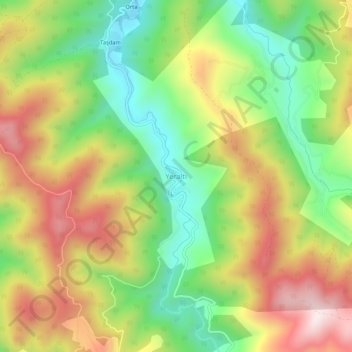
Name: Yeraltı topographic map, elevation, terrain.
Location: Yeraltı, Bafra, Samsun, Black Sea Region, Turkey (41.35189 35.84246 41.39189 35.88246)
Average elevation: 1,309 ft
Minimum elevation: 446 ft
Maximum elevation: 2,326 ft
Thank you for supporting this site ❤️
Make a donation
Make a donation
Gear up for your next adventure:
As an Amazon Associate, this site earns from qualifying purchases at no extra cost to you.