Geolocate

Ognaj topographic map

Click on the map to display elevation.

About this map

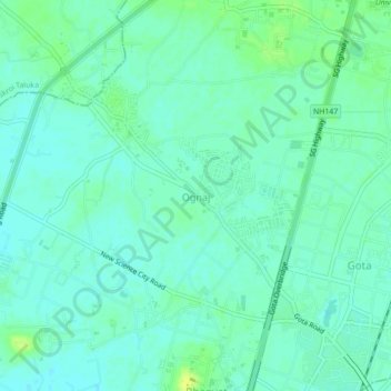
Name: Ognaj topographic map, elevation, terrain.

Location: Ognaj, Ghatlodiya Taluka, Ahmedabad, Gujarat, 380060, India (23.09779 72.49368 23.13779 72.53368)

Average elevation: 187 ft

Minimum elevation: 167 ft

Maximum elevation: 210 ft

Other topographic maps

Click on a map to view its topography, its elevation and its terrain.

Science City

India > Gujarat > Ghatlodiya Taluka > Bhadaj

Average elevation: 171 ft

Thaltej Lake

India > Gujarat > Ghatlodiya Taluka

Average elevation: 174 ft

Chharodi Park

India > Gujarat > Ghatlodiya Taluka

Average elevation: 194 ft

Gear up for your next adventure:

💧Water Filtration Bottles - Safely drink from streams and lakes while exploring
Solar GPS Watches - Advanced multisport watches with built-in topographic maps
🧼Biodegradable Camping Soap - Eco‑friendly soap for outdoor hygiene
🔭Compact Binoculars - HD vision for scouting terrain and identifying distant landmarks
🔊Portable Camp Speaker - Music and alerts at camp

As an Amazon Associate, this site earns from qualifying purchases at no extra cost to you.