Geolocate

Odiham topographic map

Click on the map to display elevation.

About this map

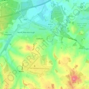
Name: Odiham topographic map, elevation, terrain.

Location: Odiham, Hart, Hampshire, England, United Kingdom (51.22058 -0.97484 51.27859 -0.88233)

Average elevation: 322 ft

Minimum elevation: 210 ft

Maximum elevation: 528 ft

Other topographic maps

Click on a map to view its topography, its elevation and its terrain.

Hillside

United Kingdom > England > Hampshire > Hart > Odiham

Average elevation: 322 ft

Gear up for your next adventure:

🦺Reflective Outdoor Gear - Safety gear for low‑light conditions
🎒Hydration Pack - Hands‑free water reservoir for long hikes
Backpacking Tent - Lightweight and durable tent for multi‑day hikes
🔭Compact Binoculars - HD vision for scouting terrain and identifying distant landmarks
🧦Hiking Socks - Comfortable socks to prevent blisters on long hikes

As an Amazon Associate, this site earns from qualifying purchases at no extra cost to you.