
Berg topographic map
Click on the map to display elevation.
About this map
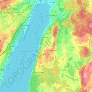
Name: Berg topographic map, elevation, terrain.
Location: Berg, Landkreis Starnberg, Bavaria, 82335, Germany (47.91935 11.33441 47.99999 11.42895)
Average elevation: 2,067 ft
Minimum elevation: 1,906 ft
Maximum elevation: 2,333 ft
Other topographic maps
Click on a map to view its topography, its elevation and its terrain.
Whirlpool
Germany > Bavaria > Landkreis Starnberg > Gauting > Königswiesen
Average elevation: 1,932 ft
Stockerbichl
Germany > Bavaria > Landkreis Starnberg > Tutzing > Unterzeismering
Average elevation: 2,080 ft
5er-Grube
Germany > Bavaria > Landkreis Starnberg > Krailling > Kraillinger Innovations Meile KIM
Average elevation: 1,844 ft