Geolocate

Hancock topographic map

Click on the map to display elevation.

About this map

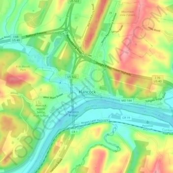
Name: Hancock topographic map, elevation, terrain.

Location: Hancock, Washington County, Maryland, 21750, United States (39.68065 -78.20226 39.72065 -78.16226)

Average elevation: 545 ft

Minimum elevation: 381 ft

Maximum elevation: 751 ft

Washington County trails, hiking, mountain biking, running and outdoor activities

Gear up for your next adventure:

🎒Hydration Pack - Hands‑free water reservoir for long hikes
📦Dry Bags Set - Waterproof storage for electronics and clothes
🧭GPS Watch Accessories - Bands and chargers for GPS watches
🦺Reflective Outdoor Gear - Safety gear for low‑light conditions
📷Action Camera - Capture your outdoor adventures in HD

As an Amazon Associate, this site earns from qualifying purchases at no extra cost to you.