Geolocate

Baeza topographic map

Click on the map to display elevation.

About this map

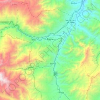
Name: Baeza topographic map, elevation, terrain.

Location: Baeza, Quijos, Napo, 150750, Ecuador (-0.53920 -78.06765 -0.43516 -77.84930)

Average elevation: 8,261 ft

Minimum elevation: 5,039 ft

Maximum elevation: 14,114 ft

Other topographic maps

Click on a map to view its topography, its elevation and its terrain.

Puntas

Ecuador > Napo > Quijos > Cuyuja

Average elevation: 12,838 ft

Gear up for your next adventure:

🏫Relief Map Kits - Hands-on tools for teaching landforms and elevation
🪶Survival Guide Book - Expert advice for emergency preparedness
💧Water Purification System - Clean water on the trail with reliable purifiers
🎒Trail Energy Bars - High‑calorie bars for hiking energy
🛡️Insect Repellent - Protection against bugs during outdoor activities

As an Amazon Associate, this site earns from qualifying purchases at no extra cost to you.