
Thank you for supporting this site ❤️
Make a donation
Make a donation
Gear up for your next adventure:
As an Amazon Associate, this site earns from qualifying purchases at no extra cost to you.
Valparaiso topographic map
Click on the map to display elevation.
Thank you for supporting this site ❤️
Make a donation
Make a donation
Gear up for your next adventure:
As an Amazon Associate, this site earns from qualifying purchases at no extra cost to you.
About this map
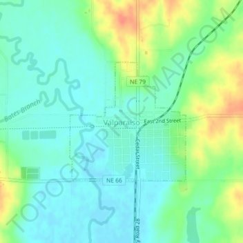
Name: Valparaiso topographic map, elevation, terrain.
Location: Valparaiso, Saunders County, Nebraska, United States (41.07488 -96.84185 41.08809 -96.82470)
Average elevation: 1,335 ft
Minimum elevation: 1,286 ft
Maximum elevation: 1,437 ft
Saunders County trails, hiking, mountain biking, running and outdoor activities
Thank you for supporting this site ❤️
Make a donation
Make a donation
Gear up for your next adventure:
As an Amazon Associate, this site earns from qualifying purchases at no extra cost to you.