
Make a donation
Gear up for your next adventure:
As an Amazon Associate, this site earns from qualifying purchases at no extra cost to you.
Malekula topographic map
Click on the map to display elevation.
Make a donation
Gear up for your next adventure:
As an Amazon Associate, this site earns from qualifying purchases at no extra cost to you.
Malekula
Malakula has a maximum elevation of 879 m. Its peak is called Mt. Liambele. In 1768, Louis Antoine de Bougainville gave his name to the straits that separate Malakula from Santo.
Make a donation
Gear up for your next adventure:
As an Amazon Associate, this site earns from qualifying purchases at no extra cost to you.
About this map
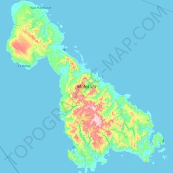
Name: Malekula topographic map, elevation, terrain.
Location: Malekula, Malampa, Vanuatu (-16.58954 167.15358 -15.87878 167.83526)
Average elevation: 226 ft
Minimum elevation: 0 ft
Maximum elevation: 2,766 ft
Make a donation
Gear up for your next adventure:
As an Amazon Associate, this site earns from qualifying purchases at no extra cost to you.
Other topographic maps
Click on a map to view its topography, its elevation and its terrain.