Geolocate

Wadi Musa topographic map

Click on the map to display elevation.

About this map

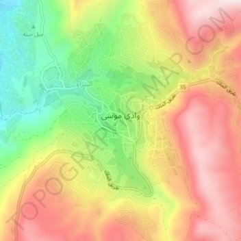
Name: Wadi Musa topographic map, elevation, terrain.

Location: Wadi Musa, Maan, Jordan (30.30481 35.46588 30.33681 35.49924)

Average elevation: 4,052 ft

Minimum elevation: 3,146 ft

Maximum elevation: 4,839 ft

Gear up for your next adventure:

🧯Portable Fire Pit - Compact fire pit for camping spots
🪵Folding Camp Saw - Compact saw for wood and campsite work
🔦Powerful Headlamps - Ultra-bright hands-free lighting for night navigation
🎒Waterproof Dry Bags - Keep your electronics and maps dry inside your pack
🔥Plasma Lighters - Windproof lighters that work in any weather condition

As an Amazon Associate, this site earns from qualifying purchases at no extra cost to you.