Geolocate

Etoile topographic map

Click on the map to display elevation.

About this map

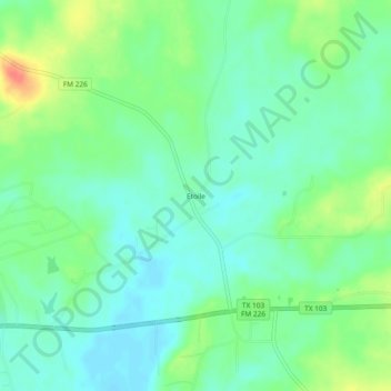
Name: Etoile topographic map, elevation, terrain.

Location: Etoile, Nacogdoches County, Texas, 75944, United States (31.36685 -94.45604 31.40685 -94.41604)

Average elevation: 210 ft

Minimum elevation: 154 ft

Maximum elevation: 322 ft

Nacogdoches County trails, hiking, mountain biking, running and outdoor activities

Other topographic maps

Click on a map to view its topography, its elevation and its terrain.

Chireno

United States > Texas > Nacogdoches County

Average elevation: 256 ft

Appleby

United States > Texas > Nacogdoches County

Average elevation: 413 ft

Appleby

United States > Texas > Nacogdoches County

Average elevation: 413 ft

Gear up for your next adventure:

🧢Sun Protection Hats - Wide-brimmed and UPF-rated hats for high-altitude sun safety
📱Solar Portable Charger - Solar power bank for charging devices off‑grid
🌧️Backpack Rain Cover - Keep gear dry in wet weather
GPS Sports Watch - GPS watch for running, hiking and training
📶Vehicle Signal Boosters - Improve reception in rural areas while driving to trailheads

As an Amazon Associate, this site earns from qualifying purchases at no extra cost to you.