
Make a donation
Gear up for your next adventure:
As an Amazon Associate, this site earns from qualifying purchases at no extra cost to you.
Remblinghausen topographic map
Click on the map to display elevation.
Make a donation
Gear up for your next adventure:
As an Amazon Associate, this site earns from qualifying purchases at no extra cost to you.
About this map
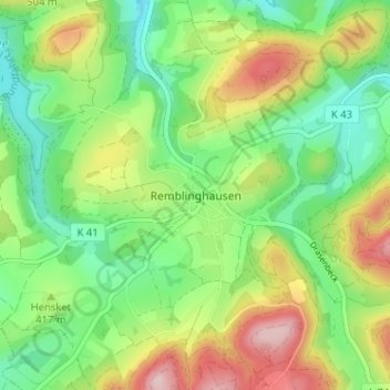
Name: Remblinghausen topographic map, elevation, terrain.
Average elevation: 1,345 ft
Minimum elevation: 1,001 ft
Maximum elevation: 1,916 ft
Make a donation
Gear up for your next adventure:
As an Amazon Associate, this site earns from qualifying purchases at no extra cost to you.
Other topographic maps
Click on a map to view its topography, its elevation and its terrain.
Arnsberger Wald
Deutschland > Nordrhein-Westfalen > Hochsauerlandkreis > Meschede
Alert | Am Bocksbart | Arnsberger Wald | Battenberg / Wiemecke | Beringer Berg | Bormecke | Braberg / Wolfsloch | Döring | Drüerberg | Ennecker Bruch | Faules Siepen | Freienohler Ruhrtal | Gebke-Quellläufe | Grube Alexander | Hamorsbruch / Bermecke | Hellenkrügel | Hestrige | Hinterm Müll | Hoemmern |…
Average elevation: 1,211 ft