Geolocate

Girvan topographic map

Click on the map to display elevation.

About this map

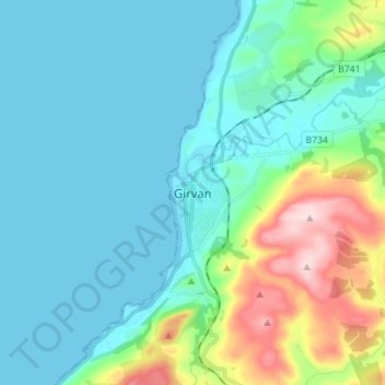
Name: Girvan topographic map, elevation, terrain.

Location: Girvan, South Ayrshire, Scotland, KA26 9BS, United Kingdom (55.20132 -4.89536 55.28132 -4.81536)

Average elevation: 197 ft

Minimum elevation: 0 ft

Maximum elevation: 971 ft

Other topographic maps

Click on a map to view its topography, its elevation and its terrain.

Sundrum Castle

United Kingdom > Scotland > South Ayrshire > Coylton

Average elevation: 207 ft

Gear up for your next adventure:

🔊Portable Camp Speaker - Music and alerts at camp
👟Trail Running Shoes - Lightweight shoes for trail runners
🪶LED Camping Lantern - Bright lantern for camp lighting
🚑Emergency Bivvies - Heat-reflective sleeping bags for survival situations
🧷Carabiner Set - Durable clips for gear attachment

As an Amazon Associate, this site earns from qualifying purchases at no extra cost to you.