
Make a donation
Gear up for your next adventure:
As an Amazon Associate, this site earns from qualifying purchases at no extra cost to you.
Brooklyn topographic map
Click on the map to display elevation.
Make a donation
Gear up for your next adventure:
As an Amazon Associate, this site earns from qualifying purchases at no extra cost to you.
Brooklyn
Brooklyn’s topography is shaped by its position on western Long Island, where low coastal plains, harbor margins, and glacial landforms meet in a densely urbanized landscape. Much of southern and eastern Brooklyn forms a gently sloping outwash plain that descends toward Jamaica Bay, Coney Island, Gravesend Bay, and the Atlantic-facing shore, while the central and northwestern parts rise into a modest but distinct belt of hills associated with the terminal moraine that runs through Brooklyn and Queens. This moraine gives areas around Prospect Park, Park Slope, Sunset Park, and Green-Wood Cemetery a more rolling physical character, with short ridges, knolls, and locally sharper relief compared with the flatter coastal neighborhoods. Green-Wood’s Battle Hill is widely identified as Brooklyn’s highest natural point, standing a little over 200 ft above sea level, and it illustrates how the borough’s most pronounced elevations are glacial rather than bedrock mountain forms. Overall, Brooklyn presents a subdued but varied urban terrain: low tidal edges and reclaimed waterfronts around the harbor, broad sandy plains toward the south, and a central moraine ridge that provides the borough’s main elevation contrast and long views across New York Harbor.
Make a donation
Gear up for your next adventure:
As an Amazon Associate, this site earns from qualifying purchases at no extra cost to you.
About this map
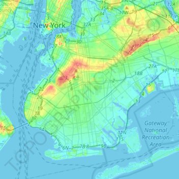
Name: Brooklyn topographic map, elevation, terrain.
Location: Brooklyn, Kings County, New York, United States (40.55034 -74.05669 40.73943 -73.83295)
Average elevation: 30 ft
Minimum elevation: -33 ft
Maximum elevation: 203 ft
Kings County trails, hiking, mountain biking, running and outdoor activities
Make a donation
Gear up for your next adventure:
As an Amazon Associate, this site earns from qualifying purchases at no extra cost to you.
Other topographic maps
Click on a map to view its topography, its elevation and its terrain.
Brooklyn Bridge Park
United States > New York > Kings County > New York
Brooklyn Bridge Park spans 85 acres (34 ha) of the East River waterfront in the Brooklyn Heights and Dumbo neighborhoods of Brooklyn. The park is divided into eleven sections: Piers 1 through 6; Fulton Ferry Landing; Brooklyn Bridge Plaza; Empire Fulton Ferry; Main Street; and John Street. Each of these…
Average elevation: 30 ft
Make a donation
Gear up for your next adventure:
As an Amazon Associate, this site earns from qualifying purchases at no extra cost to you.