Geolocate

Drewsteignton topographic map

Click on the map to display elevation.

About this map

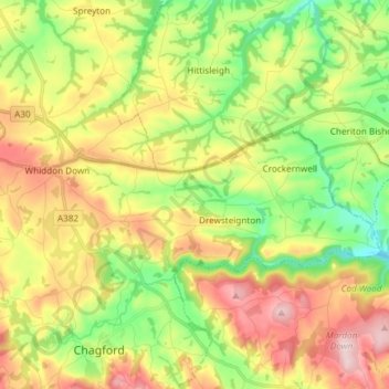
Name: Drewsteignton topographic map, elevation, terrain.

Location: Drewsteignton, West Devon, Devon, England, United Kingdom (50.68906 -3.88127 50.73217 -3.73227)

Average elevation: 666 ft

Minimum elevation: 272 ft

Maximum elevation: 1,168 ft

Other topographic maps

Click on a map to view its topography, its elevation and its terrain.

Castle Drogo

United Kingdom > England > Devon > West Devon > Drewsteignton

Average elevation: 673 ft

Gear up for your next adventure:

🔦Powerful Headlamps - Ultra-bright hands-free lighting for night navigation
🦶Carbon Trekking Poles - Reduce knee impact on steep descents with ultra-light poles
🧤Tactile Hiking Gloves - Keep hands warm while operating GPS and smartphone screens
🔥Fast-Boil Camping Stoves - Efficient cooking systems for quick trail meals
🪶Camping Sleeping Pad - Comfortable sleeping pad for backpacking

As an Amazon Associate, this site earns from qualifying purchases at no extra cost to you.