
Make a donation
Gear up for your next adventure:
As an Amazon Associate, this site earns from qualifying purchases at no extra cost to you.
Westkerke topographic map
Click on the map to display elevation.
Make a donation
Gear up for your next adventure:
As an Amazon Associate, this site earns from qualifying purchases at no extra cost to you.
Westkerke
Westkerke ligt op een dekzandrug die zich op een uit het tertiair stammende getuigenheuvel heeft afgezet. De hoogte bedraagt ongeveer 8 meter. Ten zuiden van Westkerke strekt zich nog polderland uit, dat ontwaterd wordt door de Bourgognevaart en de Moerdijkvaart. De Reigerie is een vogelreservaat.
Make a donation
Gear up for your next adventure:
As an Amazon Associate, this site earns from qualifying purchases at no extra cost to you.
About this map
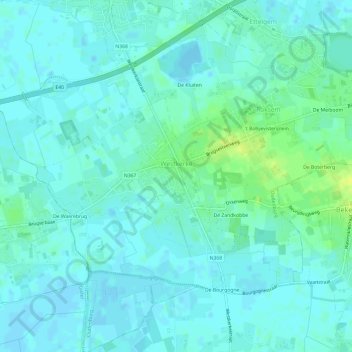
Name: Westkerke topographic map, elevation, terrain.
Average elevation: 13 ft
Minimum elevation: -10 ft
Maximum elevation: 52 ft
Make a donation
Gear up for your next adventure:
As an Amazon Associate, this site earns from qualifying purchases at no extra cost to you.
Other topographic maps
Click on a map to view its topography, its elevation and its terrain.
De Meiboom
België > West-Vlaanderen > Oostende > Oudenburg > Roksem > De Meiboom
Average elevation: 20 ft