
Make a donation
Gear up for your next adventure:
As an Amazon Associate, this site earns from qualifying purchases at no extra cost to you.
Mougins topographic map
Click on the map to display elevation.
Make a donation
Gear up for your next adventure:
As an Amazon Associate, this site earns from qualifying purchases at no extra cost to you.
About this map
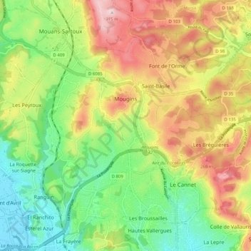
Name: Mougins topographic map, elevation, terrain.
Average elevation: 449 ft
Minimum elevation: 10 ft
Maximum elevation: 1,027 ft
Make a donation
Gear up for your next adventure:
As an Amazon Associate, this site earns from qualifying purchases at no extra cost to you.
Other topographic maps
Click on a map to view its topography, its elevation and its terrain.
Pont du Loup
France > Provence-Alpes-Côte d'Azur > Maritime Alps > Tourrettes-sur-Loup
Average elevation: 1,991 ft
Cime de la Bonette
France > Provence-Alpes-Côte d'Azur > Maritime Alps > Saint-Dalmas-le-Selvage
Average elevation: 8,241 ft
Col de Nice
France > Provence-Alpes-Côte d'Azur > Maritime Alps > L'Escarène
Average elevation: 1,463 ft
Make a donation
Gear up for your next adventure:
As an Amazon Associate, this site earns from qualifying purchases at no extra cost to you.
Les Galants
France > Provence-Alpes-Côte d'Azur > Maritime Alps > Escragnolles
Average elevation: 3,799 ft
Make a donation
Gear up for your next adventure:
As an Amazon Associate, this site earns from qualifying purchases at no extra cost to you.
La Sagne
France > Provence-Alpes-Côte d'Azur > Maritime Alps > Briançonnet
Average elevation: 4,055 ft
Berghe Inférieur
France > Provence-Alpes-Côte d'Azur > Maritime Alps > Fontan
Average elevation: 3,159 ft
Roya
France > Provence-Alpes-Côte d'Azur > Maritime Alps > Saint-Étienne-de-Tinée > Roya
Average elevation: 6,093 ft
Make a donation
Gear up for your next adventure:
As an Amazon Associate, this site earns from qualifying purchases at no extra cost to you.