
Thank you for supporting this site ❤️
Make a donation
Make a donation
Gear up for your next adventure:
As an Amazon Associate, this site earns from qualifying purchases at no extra cost to you.
Jumantono topographic map
Click on the map to display elevation.
Thank you for supporting this site ❤️
Make a donation
Make a donation
Gear up for your next adventure:
As an Amazon Associate, this site earns from qualifying purchases at no extra cost to you.
About this map
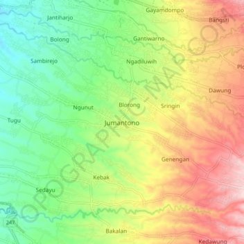
Name: Jumantono topographic map, elevation, terrain.
Location: Jumantono, Karanganyar, Central Java, Java, 57781, Indonesia (-7.69446 110.95545 -7.61446 111.03545)
Average elevation: 932 ft
Minimum elevation: 522 ft
Maximum elevation: 1,490 ft
Thank you for supporting this site ❤️
Make a donation
Make a donation
Gear up for your next adventure:
As an Amazon Associate, this site earns from qualifying purchases at no extra cost to you.