
Make a donation
Gear up for your next adventure:
As an Amazon Associate, this site earns from qualifying purchases at no extra cost to you.
Durchhausen topographic map
Click on the map to display elevation.
Make a donation
Gear up for your next adventure:
As an Amazon Associate, this site earns from qualifying purchases at no extra cost to you.
About this map
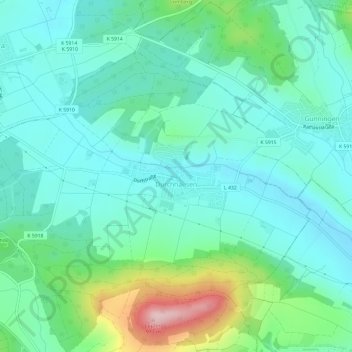
Name: Durchhausen topographic map, elevation, terrain.
Average elevation: 2,497 ft
Minimum elevation: 2,303 ft
Maximum elevation: 3,146 ft
Make a donation
Gear up for your next adventure:
As an Amazon Associate, this site earns from qualifying purchases at no extra cost to you.
Other topographic maps
Click on a map to view its topography, its elevation and its terrain.
Kirchen-Hausen
Deutschland > Baden-Württemberg > Landkreis Tuttlingen > Geisingen
Average elevation: 2,392 ft
Wilde
Deutschland > Baden-Württemberg > Landkreis Tuttlingen > Neuhausen ob Eck
Average elevation: 2,280 ft
Aixheim
Deutschland > Baden-Württemberg > Landkreis Tuttlingen
Aixheim liegt am Ostende der Baar am Rande der Schwäbischen Alb, etwa zwei Kilometer nordwestlich von Aldingen und fünf Kilometer nordöstlich von Trossingen, auf einer Höhe von 664 m ü. NN und hat 1285 Einwohner (Stand 31. Januar 2012).
Average elevation: 2,142 ft
Make a donation
Gear up for your next adventure:
As an Amazon Associate, this site earns from qualifying purchases at no extra cost to you.
Lembergturm
Deutschland > Baden-Württemberg > Landkreis Tuttlingen > Gosheim
Average elevation: 2,717 ft
Witthoh
Deutschland > Baden-Württemberg > Landkreis Tuttlingen
Der Witthoh ist ein Höhenzug (862 m ü. NHN), Aussichtsberg und Standort des Senders Witthoh südlich von Tuttlingen in Baden-Württemberg.
Average elevation: 2,638 ft
Irndorfer Hardt
Deutschland > Baden-Württemberg > Landkreis Tuttlingen > Irndorf
Average elevation: 2,871 ft
Make a donation
Gear up for your next adventure:
As an Amazon Associate, this site earns from qualifying purchases at no extra cost to you.
Klippeneck (NSG)
Deutschland > Baden-Württemberg > Landkreis Tuttlingen > Denkingen
Average elevation: 2,782 ft
Basaltkegel
Deutschland > Baden-Württemberg > Landkreis Tuttlingen > Geisingen > Leipferdingen
Average elevation: 2,474 ft
Seitingen
Deutschland > Baden-Württemberg > Landkreis Tuttlingen > Seitingen-Oberflacht
Average elevation: 2,628 ft
Leipferdingen
Deutschland > Baden-Württemberg > Landkreis Tuttlingen > Geisingen
Average elevation: 2,474 ft
Make a donation
Gear up for your next adventure:
As an Amazon Associate, this site earns from qualifying purchases at no extra cost to you.
Hattingen
Deutschland > Baden-Württemberg > Landkreis Tuttlingen > Hattingen
Average elevation: 2,431 ft
Höwenegg
Deutschland > Baden-Württemberg > Landkreis Tuttlingen > Immendingen
Average elevation: 2,490 ft
Hintschingen
Deutschland > Baden-Württemberg > Landkreis Tuttlingen > Hintschingen
Average elevation: 2,451 ft
Make a donation
Gear up for your next adventure:
As an Amazon Associate, this site earns from qualifying purchases at no extra cost to you.
Wartenberg
Deutschland > Baden-Württemberg > Landkreis Tuttlingen > Geisingen
Average elevation: 2,313 ft
Seitingen-Oberflacht
Deutschland > Baden-Württemberg > Landkreis Tuttlingen
Average elevation: 2,457 ft
Zundelberg
Deutschland > Baden-Württemberg > Landkreis Tuttlingen > Spaichingen
Average elevation: 2,680 ft
Make a donation
Gear up for your next adventure:
As an Amazon Associate, this site earns from qualifying purchases at no extra cost to you.
Witthoh
Deutschland > Baden-Württemberg > Landkreis Tuttlingen
Der Witthoh ist ein Höhenzug (862 m ü. NHN), Aussichtsberg und Standort des Senders Witthoh südlich von Tuttlingen in Baden-Württemberg.
Average elevation: 2,638 ft