
Make a donation
Gear up for your next adventure:
As an Amazon Associate, this site earns from qualifying purchases at no extra cost to you.
Mayiladuthurai topographic map
Click on the map to display elevation.
Make a donation
Gear up for your next adventure:
As an Amazon Associate, this site earns from qualifying purchases at no extra cost to you.
Mayiladuthurai
Mayliladuthurai is situated at a distance of 281 kilometres (175 mi) from Chennai and 122 kilometres (76 mi) from Tiruchirappalli. The town is located at 11°06′N 79°39′E / 11.10°N 79.65°E / 11.10; 79.65. Situated at a distance of 24 kilometres (15 mi) from the Bay of Bengal coast, the town is situated at an altitude of barely 10 metres (33 ft) above mean sea level. The Kaveri River runs through the town bisecting it into Uttara Mayuram and Mayuram proper. Most of the town lies to the south of the river and the Mayuranathaswami Temple lies a mile to its south. The famous Parimala Ranganatha Perumal temple is situated at Tiruindalur, which lies North of Cauvery river. There is a bathing ghat on the Cauvery river. Agriculture is the most widely practised occupation.
Make a donation
Gear up for your next adventure:
As an Amazon Associate, this site earns from qualifying purchases at no extra cost to you.
About this map
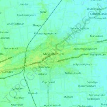
Name: Mayiladuthurai topographic map, elevation, terrain.
Location: Mayiladuthurai, Tamil Nadu, 609129, India (11.06186 79.61032 11.14186 79.69032)
Average elevation: 33 ft
Minimum elevation: 20 ft
Maximum elevation: 59 ft
Make a donation
Gear up for your next adventure:
As an Amazon Associate, this site earns from qualifying purchases at no extra cost to you.
Other topographic maps
Click on a map to view its topography, its elevation and its terrain.