
Thank you for supporting this site ❤️
Make a donation
Make a donation
Gear up for your next adventure:
As an Amazon Associate, this site earns from qualifying purchases at no extra cost to you.
Ranc topographic map
Click on the map to display elevation.
Thank you for supporting this site ❤️
Make a donation
Make a donation
Gear up for your next adventure:
As an Amazon Associate, this site earns from qualifying purchases at no extra cost to you.
About this map
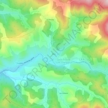
Name: Ranc topographic map, elevation, terrain.
Average elevation: 3,599 ft
Minimum elevation: 3,205 ft
Maximum elevation: 4,327 ft
Thank you for supporting this site ❤️
Make a donation
Make a donation
Gear up for your next adventure:
As an Amazon Associate, this site earns from qualifying purchases at no extra cost to you.
Other topographic maps
Click on a map to view its topography, its elevation and its terrain.
07590
France > Auvergne-Rhône-Alpes > Ardèche > Saint-Étienne-de-Lugdarès > La Chaze
Average elevation: 3,707 ft
Ruisseau de Rabeyral
France > Auvergne-Rhône-Alpes > Ardèche > Saint-Étienne-de-Lugdarès > Les Hubacs
Average elevation: 3,707 ft