
Make a donation
Gear up for your next adventure:
As an Amazon Associate, this site earns from qualifying purchases at no extra cost to you.
Ottenhöfen topographic map
Click on the map to display elevation.
Make a donation
Gear up for your next adventure:
As an Amazon Associate, this site earns from qualifying purchases at no extra cost to you.
Ottenhöfen
Das Zehn-Täler-Dorf Ottenhöfen im Schwarzwald liegt im Achertal zwischen Schwarzwaldhochstraße und Badischer Weinstraße, 35 Kilometer entfernt von Straßburg/Elsass, Baden-Baden und Freudenstadt. Das Gemeindegebiet erstreckt sich auf 300 bis 1005 Meter Höhe und ist zu mehr als 50 Prozent bewaldet.
Make a donation
Gear up for your next adventure:
As an Amazon Associate, this site earns from qualifying purchases at no extra cost to you.
About this map
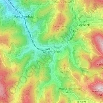
Name: Ottenhöfen topographic map, elevation, terrain.
Average elevation: 1,470 ft
Minimum elevation: 755 ft
Maximum elevation: 2,467 ft
Make a donation
Gear up for your next adventure:
As an Amazon Associate, this site earns from qualifying purchases at no extra cost to you.
Other topographic maps
Click on a map to view its topography, its elevation and its terrain.
77883
Deutschland > Baden-Württemberg > Ortenaukreis > Ottenhöfen im Schwarzwald > Ottenhöfen
Average elevation: 1,923 ft