
Make a donation
Gear up for your next adventure:
As an Amazon Associate, this site earns from qualifying purchases at no extra cost to you.
Kiełkowice topographic map
Click on the map to display elevation.
Make a donation
Gear up for your next adventure:
As an Amazon Associate, this site earns from qualifying purchases at no extra cost to you.
About this map
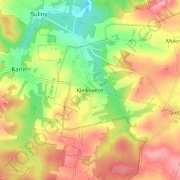
Name: Kiełkowice topographic map, elevation, terrain.
Average elevation: 1,283 ft
Minimum elevation: 1,106 ft
Maximum elevation: 1,437 ft
Make a donation
Gear up for your next adventure:
As an Amazon Associate, this site earns from qualifying purchases at no extra cost to you.
Other topographic maps
Click on a map to view its topography, its elevation and its terrain.
Okiennik Wielki
Poland > Silesian Voivodeship > Zawiercie County > Piaseczno
Average elevation: 1,273 ft
Park Krajobrazowy Orlich Gniazd
Poland > Silesian Voivodeship > Zawiercie County > Rzędkowice
Average elevation: 1,017 ft
Make a donation
Gear up for your next adventure:
As an Amazon Associate, this site earns from qualifying purchases at no extra cost to you.