Make a donation
Gear up for your next adventure:
As an Amazon Associate, this site earns from qualifying purchases at no extra cost to you.
Dunsfold topographic map
Click on the map to display elevation.
Make a donation
Gear up for your next adventure:
As an Amazon Associate, this site earns from qualifying purchases at no extra cost to you.
Dunsfold
St Mary & All Saints' Church is a Norman building, containing the oldest pews in England. The nearby Holy Well was a site of pilgrimage – its waters were thought to cure diseases of the eye. It would be consistent with the topography of the site that the well be a pre-Christian site and the church itself be constructed on a man-made hill of pre-Christian origin.
Make a donation
Gear up for your next adventure:
As an Amazon Associate, this site earns from qualifying purchases at no extra cost to you.
About this map
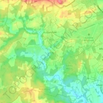
Name: Dunsfold topographic map, elevation, terrain.
Location: Dunsfold, Waverley, Surrey, England, United Kingdom (51.07968 -0.59778 51.13305 -0.53668)
Average elevation: 171 ft
Minimum elevation: 72 ft
Maximum elevation: 318 ft
Make a donation
Gear up for your next adventure:
As an Amazon Associate, this site earns from qualifying purchases at no extra cost to you.
Other topographic maps
Click on a map to view its topography, its elevation and its terrain.
Make a donation
Gear up for your next adventure:
As an Amazon Associate, this site earns from qualifying purchases at no extra cost to you.
Make a donation
Gear up for your next adventure:
As an Amazon Associate, this site earns from qualifying purchases at no extra cost to you.
Hankley Common
United Kingdom > England > Surrey > Waverley > Thursley > Truxford
Average elevation: 230 ft
Make a donation
Gear up for your next adventure:
As an Amazon Associate, this site earns from qualifying purchases at no extra cost to you.
Make a donation
Gear up for your next adventure:
As an Amazon Associate, this site earns from qualifying purchases at no extra cost to you.
Camelsdale
United Kingdom > England > Surrey > Waverley > Haslemere > Shottermill
Average elevation: 545 ft
Make a donation
Gear up for your next adventure:
As an Amazon Associate, this site earns from qualifying purchases at no extra cost to you.
Make a donation
Gear up for your next adventure:
As an Amazon Associate, this site earns from qualifying purchases at no extra cost to you.
Lakers Green
United Kingdom > England > Surrey > Waverley > Alfold Crossways
Average elevation: 180 ft
Make a donation
Gear up for your next adventure:
As an Amazon Associate, this site earns from qualifying purchases at no extra cost to you.
Floodplain (seasonal)
United Kingdom > England > Surrey > Waverley > Farnham > Wrecclesham
Average elevation: 308 ft
Make a donation
Gear up for your next adventure:
As an Amazon Associate, this site earns from qualifying purchases at no extra cost to you.
