
Thank you for supporting this site ❤️
Make a donation
Make a donation
Gear up for your next adventure:
As an Amazon Associate, this site earns from qualifying purchases at no extra cost to you.
Piton des Neiges topographic map
Click on the map to display elevation.
Thank you for supporting this site ❤️
Make a donation
Make a donation
Gear up for your next adventure:
As an Amazon Associate, this site earns from qualifying purchases at no extra cost to you.
Piton des Neiges
Le piton des Neiges est le point culminant de l'île de La Réunion (France), à 3 070 mètres d'altitude. Il est parfois considéré comme le point culminant de l'océan Indien.
Thank you for supporting this site ❤️
Make a donation
Make a donation
Gear up for your next adventure:
As an Amazon Associate, this site earns from qualifying purchases at no extra cost to you.
About this map
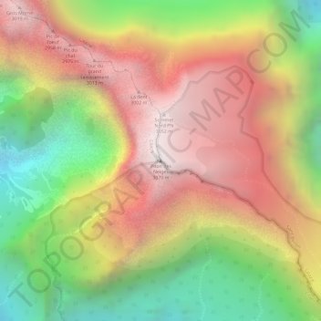
Name: Piton des Neiges topographic map, elevation, terrain.
Average elevation: 8,091 ft
Minimum elevation: 5,705 ft
Maximum elevation: 10,046 ft
Thank you for supporting this site ❤️
Make a donation
Make a donation
Gear up for your next adventure:
As an Amazon Associate, this site earns from qualifying purchases at no extra cost to you.