
Make a donation
Gear up for your next adventure:
As an Amazon Associate, this site earns from qualifying purchases at no extra cost to you.
Bronkhorstspruit topographic map
Click on the map to display elevation.
Make a donation
Gear up for your next adventure:
As an Amazon Associate, this site earns from qualifying purchases at no extra cost to you.
About this map
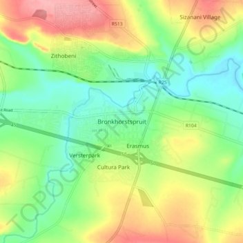
Name: Bronkhorstspruit topographic map, elevation, terrain.
Average elevation: 4,629 ft
Minimum elevation: 4,488 ft
Maximum elevation: 4,829 ft
Make a donation
Gear up for your next adventure:
As an Amazon Associate, this site earns from qualifying purchases at no extra cost to you.
Other topographic maps
Click on a map to view its topography, its elevation and its terrain.
Hennops
South Africa > Gauteng > City of Tshwane Metropolitan Municipality
Average elevation: 4,872 ft
Bronkhorstspruit Dam
South Africa > Gauteng > City of Tshwane Metropolitan Municipality
Average elevation: 4,797 ft
Rietvlei Dam
South Africa > Gauteng > City of Tshwane Metropolitan Municipality > Doornkloof East
Average elevation: 4,885 ft
Bronkhorstspruit
South Africa > Gauteng > City of Tshwane Metropolitan Municipality
Average elevation: 4,928 ft
Make a donation
Gear up for your next adventure:
As an Amazon Associate, this site earns from qualifying purchases at no extra cost to you.
Centurion Lake
South Africa > Gauteng > City of Tshwane Metropolitan Municipality > Centurion
Average elevation: 4,724 ft
Roodeplaat Dam
South Africa > Gauteng > City of Tshwane Metropolitan Municipality
Average elevation: 3,983 ft
Tshwane Ward 105
South Africa > Gauteng > City of Tshwane Metropolitan Municipality
Average elevation: 4,731 ft
Morula View Park
South Africa > Gauteng > City of Tshwane Metropolitan Municipality
Average elevation: 3,940 ft
Make a donation
Gear up for your next adventure:
As an Amazon Associate, this site earns from qualifying purchases at no extra cost to you.
Wierda Glen
South Africa > Gauteng > City of Tshwane Metropolitan Municipality > Simarlo AH
Average elevation: 4,852 ft
Danville
South Africa > Gauteng > City of Tshwane Metropolitan Municipality > Pretoria
Average elevation: 4,432 ft
Roodeplaat Dam
South Africa > Gauteng > City of Tshwane Metropolitan Municipality
Average elevation: 3,983 ft
Tshwane Ward 91
South Africa > Gauteng > City of Tshwane Metropolitan Municipality
Average elevation: 4,964 ft
Make a donation
Gear up for your next adventure:
As an Amazon Associate, this site earns from qualifying purchases at no extra cost to you.
Tshwane Ward 100
South Africa > Gauteng > City of Tshwane Metropolitan Municipality
Average elevation: 4,619 ft
Tshwane Ward 30
South Africa > Gauteng > City of Tshwane Metropolitan Municipality
Average elevation: 3,957 ft
Tshwane Ward 65
South Africa > Gauteng > City of Tshwane Metropolitan Municipality
Average elevation: 4,879 ft
Tshwane Ward 54
South Africa > Gauteng > City of Tshwane Metropolitan Municipality
Average elevation: 4,222 ft
Make a donation
Gear up for your next adventure:
As an Amazon Associate, this site earns from qualifying purchases at no extra cost to you.
Himalya Street Park
South Africa > Gauteng > City of Tshwane Metropolitan Municipality > Pretoria
Average elevation: 4,777 ft
Hennops
South Africa > Gauteng > City of Tshwane Metropolitan Municipality
Average elevation: 4,872 ft
Tshwane Ward 53
South Africa > Gauteng > City of Tshwane Metropolitan Municipality
Average elevation: 4,304 ft
Bronkhorstspruit Dam
South Africa > Gauteng > City of Tshwane Metropolitan Municipality
Average elevation: 4,797 ft
Make a donation
Gear up for your next adventure:
As an Amazon Associate, this site earns from qualifying purchases at no extra cost to you.