
Thank you for supporting this site ❤️
Make a donation
Make a donation
Gear up for your next adventure:
As an Amazon Associate, this site earns from qualifying purchases at no extra cost to you.
Tunuyo topographic map
Click on the map to display elevation.
Thank you for supporting this site ❤️
Make a donation
Make a donation
Gear up for your next adventure:
As an Amazon Associate, this site earns from qualifying purchases at no extra cost to you.
About this map
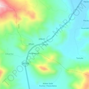
Name: Tunuyo topographic map, elevation, terrain.
Location: Tunuyo, Asillo, Azángaro, Puno, Perú (-14.86986 -70.42691 -14.82986 -70.38691)
Average elevation: 13,281 ft
Minimum elevation: 12,881 ft
Maximum elevation: 14,370 ft
Thank you for supporting this site ❤️
Make a donation
Make a donation
Gear up for your next adventure:
As an Amazon Associate, this site earns from qualifying purchases at no extra cost to you.