Geolocate

Cardigan topographic map

Click on the map to display elevation.

About this map

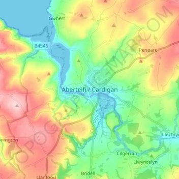
Name: Cardigan topographic map, elevation, terrain.

Location: Cardigan, Ceredigion, Wales, SA43 1JR, United Kingdom (52.04400 -4.70042 52.12400 -4.62042)

Average elevation: 266 ft

Minimum elevation: -3 ft

Maximum elevation: 679 ft

Other topographic maps

Click on a map to view its topography, its elevation and its terrain.

Penbryn

United Kingdom > Wales > Ceredigion

Average elevation: 377 ft

Gear up for your next adventure:

🦶Hiking Gaiters - Keep debris and water out of your boots
🛏️Cold Weather Sleeping Bag - Warm sleeping bag for cold conditions
🧣Hiking Neck Gaiter - Multi‑use neck protection for outdoor weather
🧭Pro Hiking Compasses - High-accuracy liquid-filled compasses for topographic orientation
🔭Stargazing Telescopes - Perfect for camping in low-light pollution areas shown on maps

As an Amazon Associate, this site earns from qualifying purchases at no extra cost to you.