
Dobl topographic map
Interactive map
Click on the map to display elevation.
About this map
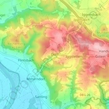
Name: Dobl topographic map, elevation, terrain.
Location: Dobl, Winzer, Landkreis Deggendorf, Bavaria, 94547, Germany (48.69626 13.10065 48.73626 13.14065)
Average elevation: 1,240 ft
Minimum elevation: 994 ft
Maximum elevation: 1,562 ft
Other topographic maps
Click on a map to view its topography, its elevation and its terrain.
Mahd
Germany > Bavaria > Landkreis Deggendorf > Osterhofen > Arbing
Mahd, Arbing, Osterhofen, Landkreis Deggendorf, Bavaria, 94550, Germany
Average elevation: 1,020 ft
Deggendorf
Germany > Bavaria > Landkreis Deggendorf
Deggendorf, Landkreis Deggendorf, Bavaria, 94469, Germany
Average elevation: 1,473 ft
Neuhausen
Germany > Bavaria > Landkreis Deggendorf
Neuhausen, Offenberg, Landkreis Deggendorf, Bavaria, 94560, Germany
Average elevation: 1,119 ft
Otzing
Germany > Bavaria > Landkreis Deggendorf
Otzing, Oberpöring (VGem), Landkreis Deggendorf, Bavaria, 94563, Germany
Average elevation: 1,076 ft
Schuhreith
Germany > Bavaria > Landkreis Deggendorf > Mimming
Schuhreith, Mimming, Hengersberg, Landkreis Deggendorf, Bavaria, 94491, Germany
Average elevation: 1,106 ft
Plattling
Germany > Bavaria > Landkreis Deggendorf
Plattling, Landkreis Deggendorf, Bavaria, 94447, Germany
Average elevation: 1,053 ft