Geolocate

Reus topographic map

Click on the map to display elevation.

About this map

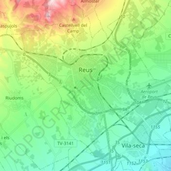
Name: Reus topographic map, elevation, terrain.

Location: Reus, Baix Camp, Tarragona, Catalonia, Spain (41.10238 1.05753 41.19021 1.19135)

Average elevation: 390 ft

Minimum elevation: 26 ft

Maximum elevation: 1,348 ft

Gear up for your next adventure:

Backpacking Tents - Weight-optimized shelters for multi-day topographic surveys
🪶Fire Starter Kit - Reliable fire starter for survival and camping
🧭Pro Hiking Compasses - High-accuracy liquid-filled compasses for topographic orientation
🪵Folding Camp Saw - Compact saw for wood and campsite work
🌲Outdoor Survival Books - Best books on survival skills

As an Amazon Associate, this site earns from qualifying purchases at no extra cost to you.