Geolocate

Barwick topographic map

Click on the map to display elevation.

About this map

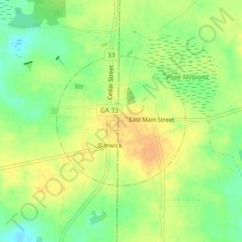
Name: Barwick topographic map, elevation, terrain.

Location: Barwick, Brooks County, Georgia, 31720, United States (30.88569 -83.74767 30.90015 -83.73089)

Average elevation: 246 ft

Minimum elevation: 184 ft

Maximum elevation: 295 ft

Brooks County trails, hiking, mountain biking, running and outdoor activities

Other topographic maps

Click on a map to view its topography, its elevation and its terrain.

Jackson Lake

United States > Georgia > Brooks County

Average elevation: 184 ft

Gear up for your next adventure:

🔋Solar Power Banks - Keep your GPS and phone charged in remote wilderness areas
🍳Camping Cook Set - Complete cookware for outdoor meals
🥾Men's Hiking Boots - Durable, waterproof footwear for rugged terrain and steep inclines
🚑Emergency Bivvies - Heat-reflective sleeping bags for survival situations
🧤Tactile Hiking Gloves - Keep hands warm while operating GPS and smartphone screens

As an Amazon Associate, this site earns from qualifying purchases at no extra cost to you.