
Thank you for supporting this site ❤️
Make a donation
Make a donation
Gear up for your next adventure:
As an Amazon Associate, this site earns from qualifying purchases at no extra cost to you.
Cumbres de Majalca topographic map
Click on the map to display elevation.
Thank you for supporting this site ❤️
Make a donation
Make a donation
Gear up for your next adventure:
As an Amazon Associate, this site earns from qualifying purchases at no extra cost to you.
About this map
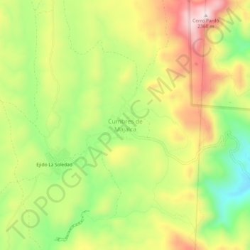
Name: Cumbres de Majalca topographic map, elevation, terrain.
Average elevation: 7,057 ft
Minimum elevation: 6,417 ft
Maximum elevation: 7,740 ft
Thank you for supporting this site ❤️
Make a donation
Make a donation
Gear up for your next adventure:
As an Amazon Associate, this site earns from qualifying purchases at no extra cost to you.
Other topographic maps
Click on a map to view its topography, its elevation and its terrain.
Ejido Tabalaopa
Mexico > Chihuahua > Municipio de Chihuahua > Chihuahua City
Average elevation: 4,528 ft
Parque El Reliz
Mexico > Chihuahua > Municipio de Chihuahua > Chihuahua City
Average elevation: 4,885 ft