
Make a donation
Gear up for your next adventure:
As an Amazon Associate, this site earns from qualifying purchases at no extra cost to you.
Lübbecke topographic map
Click on the map to display elevation.
Make a donation
Gear up for your next adventure:
As an Amazon Associate, this site earns from qualifying purchases at no extra cost to you.
Lübbecke
Am Gebirgsrand liegen die historische Altstadt sowie die alten Kerne der meisten Stadtteile. Die restlichen Gebiete sind eher dörflich geprägt. Die nördliche Stadtgrenze bildet der Mittellandkanal. Im Nordosten der Stadt liegt das Große Torfmoor, heute das größte Moor Westfalens. Zwischen den feuchten Niederungen südlich des Mittellandkanals, dem Urstromtal der eiszeitlichen Weser, und den Höhenlagen des Wiehengebirges liegt am Gebirgsfuß ein schmaler Saum fruchtbarer Lößböden mit der Bezeichnung Lübbecker Lößland. Nördlich der Niederung liegt die nicht so fruchtbare, teils sandige, teils moorige Rahden-Diepenauer Geest. In der Geest liegen die Ortschaften Stockhausen und Alswede sowie ein Teil des Lübbecker Industriegebietes.
Make a donation
Gear up for your next adventure:
As an Amazon Associate, this site earns from qualifying purchases at no extra cost to you.
About this map
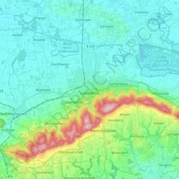
Name: Lübbecke topographic map, elevation, terrain.
Average elevation: 312 ft
Minimum elevation: 135 ft
Maximum elevation: 1,014 ft
Make a donation
Gear up for your next adventure:
As an Amazon Associate, this site earns from qualifying purchases at no extra cost to you.
Other topographic maps
Click on a map to view its topography, its elevation and its terrain.
Kappenberg
Deutschland > Nordrhein-Westfalen > Kreis Minden-Lübbecke > Bad Oeynhausen
Average elevation: 390 ft
Nettelstedt
Deutschland > Nordrhein-Westfalen > Kreis Minden-Lübbecke > Lübbecke
Average elevation: 361 ft
Babbenhausen
Deutschland > Nordrhein-Westfalen > Kreis Minden-Lübbecke > Bad Oeynhausen
Average elevation: 272 ft