Geolocate

Sweet Home topographic map

Click on the map to display elevation.

About this map

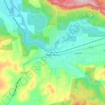
Name: Sweet Home topographic map, elevation, terrain.

Location: Sweet Home, Linn County, Oregon, 97386, United States (44.38135 -122.75193 44.41703 -122.65206)

Average elevation: 755 ft

Minimum elevation: 443 ft

Maximum elevation: 1,460 ft

Linn County trails, hiking, mountain biking, running and outdoor activities

Other topographic maps

Click on a map to view its topography, its elevation and its terrain.

Tamolitch Falls

United States > Oregon > Linn County

Average elevation: 2,864 ft

Clear Lake

United States > Oregon > Linn County

Average elevation: 3,291 ft

Cascadia

United States > Oregon > Linn County

Average elevation: 1,362 ft

Gear up for your next adventure:

Camping Coffee Makers - Enjoy premium coffee at the summit or campsite
🦶Hiking Gaiters - Keep debris and water out of your boots
🧦Merino Wool Socks - Moisture-wicking, blister-preventing socks for long treks
🛰️Handheld GPS Units - Professional satellite navigators for precise backcountry mapping
🥄Camping Utensil Set - Lightweight utensils for outdoor meals

As an Amazon Associate, this site earns from qualifying purchases at no extra cost to you.