Geolocate

Cidahu topographic map

Click on the map to display elevation.

About this map

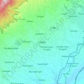
Name: Cidahu topographic map, elevation, terrain.

Location: Cidahu, Sukabumi, West Java, Java, 43358, Indonesia (-6.83308 106.69874 -6.75308 106.77874)

Average elevation: 1,952 ft

Minimum elevation: 1,293 ft

Maximum elevation: 5,098 ft

Other topographic maps

Click on a map to view its topography, its elevation and its terrain.

Cibodas

Indonesia > West Java > Sukabumi > Cimenteng

Average elevation: 853 ft

Cikahuripan

Indonesia > West Java > Sukabumi

Average elevation: 361 ft

Cisolok

Indonesia > West Java > Sukabumi

Average elevation: 203 ft

Gear up for your next adventure:

🔥Fast-Boil Camping Stoves - Efficient cooking systems for quick trail meals
🛏️Cold Weather Sleeping Bag - Warm sleeping bag for cold conditions
🦟Ultrasonic Repellers - Create a bug-free zone at your camp or rest stop
📻Weather Alert Radios - Stay informed of storm risks while off-the-grid
🎒Day Hiking Backpack - Lightweight backpack perfect for day trips and outdoor adventures

As an Amazon Associate, this site earns from qualifying purchases at no extra cost to you.