Geolocate

Inkpen topographic map

Click on the map to display elevation.

About this map

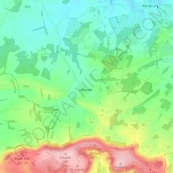
Name: Inkpen topographic map, elevation, terrain.

Location: Inkpen, West Berkshire, England, United Kingdom (51.34943 -1.52235 51.40094 -1.44772)

Average elevation: 525 ft

Minimum elevation: 302 ft

Maximum elevation: 981 ft

Gear up for your next adventure:

🚑Emergency Bivvies - Heat-reflective sleeping bags for survival situations
🧯Portable Fire Pit - Compact fire pit for camping spots
🧭Outdoor Navigation Book - Learn advanced navigation skills
📡GPS Antenna Upgrade - Enhance GPS reception in remote terrain
🛠️Backpacking Tool Kit - Essential toolkit for outdoor repairs

As an Amazon Associate, this site earns from qualifying purchases at no extra cost to you.