
Make a donation
Gear up for your next adventure:
As an Amazon Associate, this site earns from qualifying purchases at no extra cost to you.
Ausangate topographic map
Click on the map to display elevation.
Make a donation
Gear up for your next adventure:
As an Amazon Associate, this site earns from qualifying purchases at no extra cost to you.
Ausangate
Ausangate or Auzangate (in Hispanicized spellings) is a mountain of the Vilcanota mountain range in the Andes of Peru. With an elevation of 6,384 metres, it is situated around 100 kilometres southeast of Cusco in the Cusco Region, Canchis Province, Pitumarca District, and in the Quispicanchi Province, Ocongate District.
Make a donation
Gear up for your next adventure:
As an Amazon Associate, this site earns from qualifying purchases at no extra cost to you.
About this map
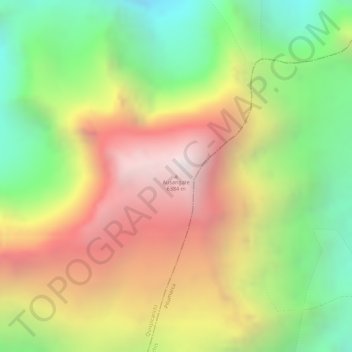
Name: Ausangate topographic map, elevation, terrain.
Average elevation: 18,428 ft
Minimum elevation: 15,991 ft
Maximum elevation: 20,863 ft
Make a donation
Gear up for your next adventure:
As an Amazon Associate, this site earns from qualifying purchases at no extra cost to you.