
Make a donation
Gear up for your next adventure:
As an Amazon Associate, this site earns from qualifying purchases at no extra cost to you.
Schildesche topographic map
Click on the map to display elevation.
Make a donation
Gear up for your next adventure:
As an Amazon Associate, this site earns from qualifying purchases at no extra cost to you.
Schildesche
Der Stadtbezirk Schildesche liegt im Ravensberger Hügelland nördlich des Teutoburger Waldes auf einer Höhe von 94 m ü. NN. Der Teutoburger Wald nimmt an der südlichen Grenze des Stadtbezirks eine Höhe bis circa 200 m an. Fließgewässer im Stadtbezirk sind der Johannisbach, der Schloßhofbach und der Sudbrackbach. Der Johannisbach wird am nordöstlichen Rand des Stadtbezirks zum Obersee gestaut.
Make a donation
Gear up for your next adventure:
As an Amazon Associate, this site earns from qualifying purchases at no extra cost to you.
About this map
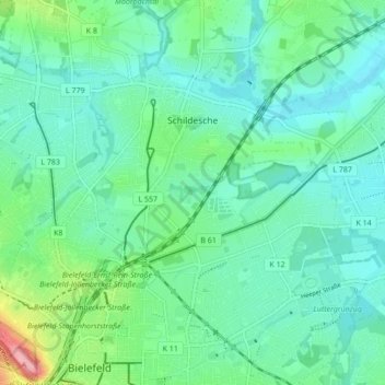
Name: Schildesche topographic map, elevation, terrain.
Location: Schildesche, Bielefeld, Nordrhein-Westfalen, Deutschland (52.02506 8.48462 52.06134 8.57069)
Average elevation: 335 ft
Minimum elevation: 249 ft
Maximum elevation: 643 ft
Make a donation
Gear up for your next adventure:
As an Amazon Associate, this site earns from qualifying purchases at no extra cost to you.
Other topographic maps
Click on a map to view its topography, its elevation and its terrain.
Burg und Festung Sparrenberg
Deutschland > Nordrhein-Westfalen > Bielefeld
Um den Erhalt und die Sanierung der Anlage finanziell sicherzustellen, wurde die Aktion Ein Stein für die Burg initiiert, bei der gegen Geldspenden die Patenschaft für einen Stein in der Burgmauer übernommen werden konnte. Bei höheren Spendensummen war eine persönliche Gravur des Steins möglich.…
Average elevation: 476 ft
Make a donation
Gear up for your next adventure:
As an Amazon Associate, this site earns from qualifying purchases at no extra cost to you.