Geolocate

Evans topographic map

Click on the map to display elevation.

About this map

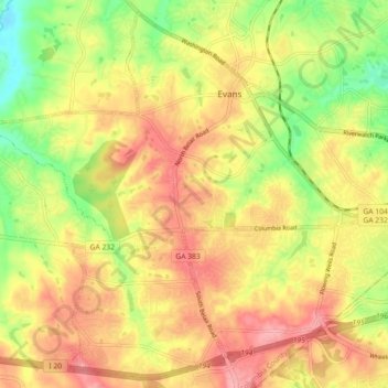
Name: Evans topographic map, elevation, terrain.

Location: Evans, Columbia County, Georgia, United States (33.47889 -82.18633 33.54978 -82.09622)

Average elevation: 381 ft

Minimum elevation: 187 ft

Maximum elevation: 535 ft

Columbia County trails, hiking, mountain biking, running and outdoor activities

Other topographic maps

Click on a map to view its topography, its elevation and its terrain.

Harlem

United States > Georgia > Columbia County

Average elevation: 486 ft

Appling

United States > Georgia > Columbia County > Appling

Average elevation: 335 ft

Snead

United States > Georgia > Columbia County

Average elevation: 289 ft

Arrow Head

United States > Georgia > Columbia County

Average elevation: 390 ft

Gear up for your next adventure:

🔭Compact Binoculars - HD vision for scouting terrain and identifying distant landmarks
🔪Outdoor Multitools - Essential survival tools for gear repair and field use
📱Solar Portable Charger - Solar power bank for charging devices off‑grid
🏥Hiking First Aid Kits - Comprehensive medical kits for remote trail injuries
🛰️Handheld GPS Units - Professional satellite navigators for precise backcountry mapping

As an Amazon Associate, this site earns from qualifying purchases at no extra cost to you.